Greenland Climate Research Centre takes the temperature at Inglefield Bredning Published 18.05.2011
Climate change and complex currents are melting glacial ice and preventing the sea from freezing off the coast of Qaanaaq.
Tracy Glacier is located in the innermost area of Inglefield Bredning, near Qaanaaq in north-west Greenland. The glacier has melted back approx. 10 km over the past 40 years and, according to local hunters, sea ice in the area has become thinner and is now forming later in the winter. This winter, for example, it was possible to travel safely on the ice in January. This is at least one month later than usual.
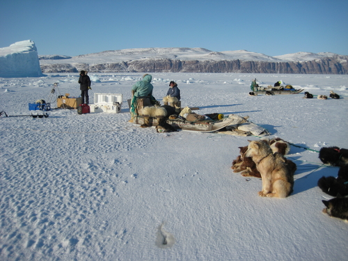
Five researchers from DMI and DTU Space and two international collaborators from the University of Southampton and the Scottish Association for Marine Science have just returned from the Qaanaaq Sea Ice Temperature Experiment (QASITEEX), which is a project directed by the Greenland Climate Research Centre. They have been measuring the water and ice in Inglefield Bredning, a fjord system that is virtually unknown to science, where even nautical charts lack depth measurements for the inner half of the fjord.
The purpose of QASITEEX, based in DMI’s laboratory in Qaanaaq was twofold: to study the temperature on the sea ice to enhance satellite temperature mapping, and to map the temperature and salinity of the water under the sea ice. In conjunction with temperature and salinity measurements, ice thicknesses were measured throughout most of the fjord.
Conditions for the formation of sea ice consist of a delicate balance between a warming effect from the sea and a cooling effect from the air. There are indications that climate change is influencing both the sea and the air – and this can have an impact on the traditional lifestyle of hunters in Qaanaaq.
Close collaboration with the hunters ensured the safety of the researchers during their work and made it possible to conduct detailed mapping of water and ice conditions throughout the fjord using dogsleds and measuring equipment.
The final branch of the Gulf Stream swings around the southern tip of Greenland, at Cape Farewell, and flows up along the west coast of Greenland through Melville Bay and into Inglefield Bredning, where the current occurs as a relatively warm and saline core at a depth of approx. 300 m under the cold and relatively fresh surface water. The ocean current’s journey ends in the innermost part of the fjord, at 77 degrees north. The Atlantic Gulf Stream waters mix with meltwater and flow out of the fjord near the surface.
This blending of the waters deep in the fjord causes the Atlantic water to lose some of its warmth, making the sea ice thinner in the innermost part of the fjord. Here it is only roughly 70 cm thick, whereas it reaches a thickness of approx. 120 cm farther out because the ice towards the mouth of the fjord is protected by the cold layer of surface water.
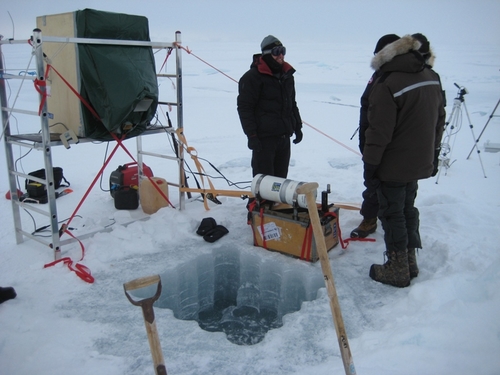
Preparations are underway for surface temperature measurements during refreezing of open water. Photo: DMI
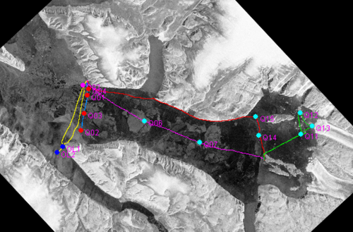
SAR image of Inglefield Bredning (23 March 2011) showing routes and measuring locations during QASITEEX fieldwork. The circles indicate the oceanographic measurement locations and the lines reflect the routes travelled, where ice thickness is measured continuously. The two circles closest to Qaanaaq (top left) also served as fixed locations for infrared and microwave measurements of surface water temperatures. Photo: DMI